The Global Hydrological system
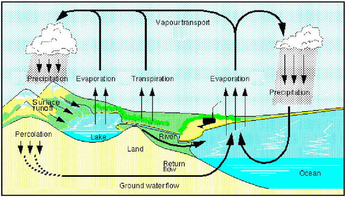 Diagram source: Max Planck Institute for Meteorology
The Global Hydrological Cycle is classified as a closed system, which means the system doesn't receive any inputs or outputs from outside of planet Earth.
- Water within the hydrological system is continually cycled between the oceans, atmosphere and land
- Water evaporates into the atmosphere, forms clouds, and is then cycled back to the oceans after falling as precipitation ( e.g. rain, snow, fog etc.).
Drainage basins
Within the global hydrological system there are local hydrological systems at work. A Drainage Basins is an example of a local hydrological system. The diagram below shows how a typical drainage basin system works.
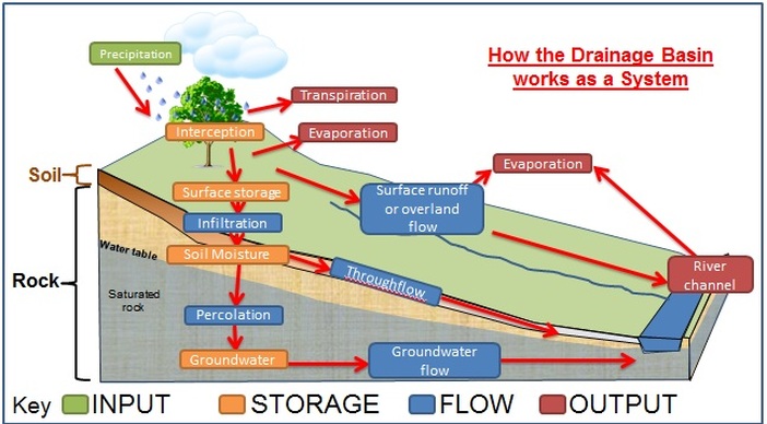
Diagram of a drainage basin system:
Source cool geography.co.uk.
- A river's drainage basin is the area surrounding the river where precipitation flows from the land into the river
- River drainage basins are also referred to as the River Catchment area
- Watershed - this is the boundary of the drainage basin. No water enters the drainage basin from beyond the watershed
- Drainage basins are open systems. This means they have inputs and outputs, water enters the system as precipitation (rain, snow, hail, dew and fog) and leaves the system through evaporation, transpiration and river discharge
Key terms
Inputs
Precipitation - all types of moisture entering the system from the atmosphere including; rain, snow, hail, frost, dew and fog.
Outputs
Evaporation - the process through which a liquid is converted into a gas (water evaporates and becomes water vapour).
Transpiration - the process of water evaporating through the leaves of plants and trees and then being returned to the atmosphere.
Evapotranspiration - is the processes of evaporation and transpiration combined.
Potential Evapotranspiration (PET) is the amount of water that could be lost through evapotranspiration during optimal conditions (where the supply of water to vegetation is continuous and uninterrupted).
Actual Evapotranspiration is, the amount of evaporation that actually takes place. (For example, in a hot desert environment PET is high due to the fact that heat increases evaporation. However, because moisture levels are low In a desert environment, actual evapotranspiration is also low.
River discharge - the river's flow.
Water Storage
Interception storage - interception is where precipitation lands on vegetation and other surfaces, before reaching the soil. Interception by vegetation can create a significant temporary store of water, especially in an area which densely is populated with trees.
Vegetation storage - water that has been taken up by, and stored within plants and trees.
Surface storage - water stored on the surface of the planet, surface storage includes; depression storage (puddles), ponds and lakes.
Groundwater storage - water which is stored in the ground, in the soil (soil moisture) or in Aquifers (porous rocks).
Aquifers are porous rocks that absorb and store water.
The Water Table lies at the top of the zone of saturation.
The zone of saturation is the area where all the pores within the soil and rocks are full of water.
Channel storage - water that is held in rivers, and stream channels.
Flows and Processes
Surface runoff is water that is flowing over the land (also referred to as overland flow). Surface runoff is common in arid areas, or where prolonged dry spells have led to the ground drying out and becoming extremely hard. Torrential rain can also lead to surface runoff, because, the rain comes down so fast that it is unable to penetrate the ground.
Throughfall - water dripping through trees or plants (leaf to leaf etc.)
Stemflow -water running down a tree trunk or plant stem.
Throughflow - water moving slowly downhill through the soil. Throughflow is faster where there are Pipes (e.g. where there are cracks in the ground or, where the roots of plants or insect lave used to be)
Infiltration - water soaking into the soil. The rate of infiltration is affected by the type of soil, soil structure and, the existing saturation level. N.B. During periods of heavy rainfall, water is unable to infiltrate the ground quickly enough, which leads to an increase in surface runoff.
Percolation - water slowly seeping down through the soil into the water table.
Groundwater flow - water flowing below the water table through permeable rocks (porous). N.B. the speed of the water flow through the rocks is determined by the type of rock.
Baseflow - groundwater that flows into rivers through the banks and river bed.
Interflow - water flowing downhill through permeable rock above the water table.
Channel flow (river discharge) - water flowing in a river or stream.
The Water Balance
- The water balance - the cyclical movement of water within the drainage basin per unit of time
- The water balance is calculated using inputs (precipitation) and outputs (evapotranspiration and channel discharge)
- There can be seasonal patterns in the water balance e.g. in the UK during wetter months, precipitation exceeds evapotranspiration creating a water surplus underground stores are topped up and this can lead to increased surface runoff, higher discharge and rising river levels. During drier months, precipitation is lower than evapotranspiration, this can lead to the depletion of ground water stores. This is the result of ground water that is flowing into rivers, being used by plants, animals and Humans before it can reach the ground water stores. A ground water deficit (shortage) which develops during a dry season is recharged (replenished) during the next wet season.
Sources
AQA (2012): AS & A2 Geography complete revision and practice all in one book
coolgeography.co.uk
MaxPlanck Institue of Meteorology
AQA (2012): AS & A2 Geography complete revision and practice all in one book
coolgeography.co.uk
MaxPlanck Institue of Meteorology
