The long profile
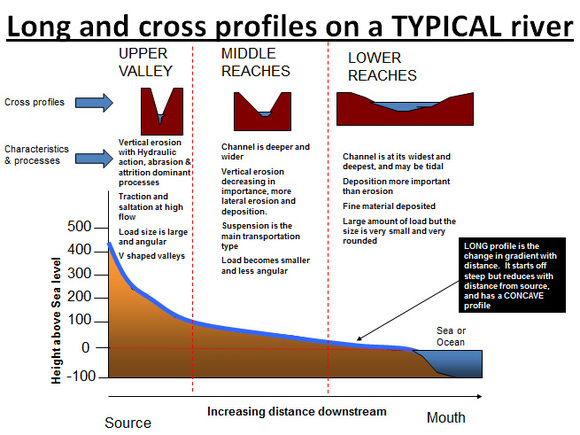
The long profile and cross profiles of a typical river. Source: cool geography.co.uk
|
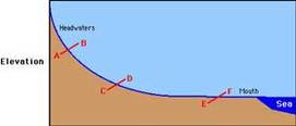
Graded profile. Source unknown
|
The long profile shows how the gradient of a river channel changes from its source, to its mouth (e.g. ocean, lake). The long profile shows the height of the river bed, above the base level, along the whole length of the river.
Base level - this is the lowest point that a river bed can be eroded to. The base level of the river is usually sea level, or the level of the lake etc. that the river is flowing into.
Over the entire course of the river the amount of erosion and deposition are balanced (total erosion equals total deposition). However, the rates of erosion and deposition vary along the course of the river, this can lead to the formation of landforms such as waterfalls and lakes (where erosion is greater than deposition), and results in an uneven long profile.
Because the rate of erosion, equals the rate of deposition over time, the long profile of the river changes from an uneven curve to a smooth curve, which is known as a graded profile.
The three stages of the river's course
The diagram above shows the river divided into three stages - upper (close to the source), middle, and lower (near to the mouth). The energy of the river varies within each stage of the river.
Upper stage - steep gradient, the river is high above sea level and has a large amount of potential energy which can be converted into other types of energy such as kinetic energy.
Middle stage - the gradient of the river decreases as you approach the middle stages, potential energy is converted into kinetic energy (movement) and the rivers velocity increases.
Lower Stage - here the river has a lot of kinetic energy, it flows quickly, but it doesn't have much potential energy.
Channel characteristics affect both velocity and discharge
As you move downstream from a river's source to it's mouth, velocity (kinetic energy) and discharge increase. Discharge increases due to tributaries (smaller rivers/streams) joining the main channel and further inputs from surface runoff as you go downstream. The river's velocity is directly influenced by gradient, rate of discharge and the characteristics of the river channel.
Kinetic energy - the largest proportion of a river's kinetic energy is used up overcoming friction. The rest of it causes erosion and is used for transportation. The greater a river's available energy for erosion and transportation, the more efficient it will be. Efficient rivers have, high velocity, high discharge and low friction.
Efficiency is measured by Hydraulic radius. The higher the hydraulic radius, the greater a river's efficiency.
Channel roughness - protruding banks and large, angular boulders on the river bed increase the wetted perimeter and increase friction, reducing efficiency, velocity and discharge.
Turbulence increases as channel roughness increases, this leads to increased erosion because turbulent flow is more efficient at picking up particles than none turbulent flow.
The upper stage of the river is where channel roughness is at it's greatest. This means that the upper stages of a river looses a lot of it's energy to friction, meaning that although the gradient of the river is steepest in this stage, discharge and velocity are at their lowest under normal conditions.
In contrast the lower stages of a river channel have smoother bed and banks, resulting in less friction and less energy loss, and, due to this discharge and velocity are greatest in the lower stages of a river.
As you move downstream from a river's source to it's mouth, velocity (kinetic energy) and discharge increase. Discharge increases due to tributaries (smaller rivers/streams) joining the main channel and further inputs from surface runoff as you go downstream. The river's velocity is directly influenced by gradient, rate of discharge and the characteristics of the river channel.
Kinetic energy - the largest proportion of a river's kinetic energy is used up overcoming friction. The rest of it causes erosion and is used for transportation. The greater a river's available energy for erosion and transportation, the more efficient it will be. Efficient rivers have, high velocity, high discharge and low friction.
Efficiency is measured by Hydraulic radius. The higher the hydraulic radius, the greater a river's efficiency.
- Hydraulic radius - channel cross-section area divided by the length of wetted perimeter (total length of the banks and river bed which are in contact with the water).
- Friction is created by contact between the water and the wetted perimeter, this increases energy loss and results in the river slowing down.
- The larger the hydraulic radius, the smaller the proportion of water in contact with the wetted perimeter,. This results in less friction, reduces energy loss, and increases velocity and discharge
- River channels that are smooth, narrow and deep have larger hydraulic radius', and are more efficient than shallow, wider river channels.
Channel roughness - protruding banks and large, angular boulders on the river bed increase the wetted perimeter and increase friction, reducing efficiency, velocity and discharge.
Turbulence increases as channel roughness increases, this leads to increased erosion because turbulent flow is more efficient at picking up particles than none turbulent flow.
The upper stage of the river is where channel roughness is at it's greatest. This means that the upper stages of a river looses a lot of it's energy to friction, meaning that although the gradient of the river is steepest in this stage, discharge and velocity are at their lowest under normal conditions.
In contrast the lower stages of a river channel have smoother bed and banks, resulting in less friction and less energy loss, and, due to this discharge and velocity are greatest in the lower stages of a river.
The cross profile
The diagram above includes cross profiles of a typical river. The cross profile shows what a cross-section of a river channel or river valley looks like. The river valley's cross profile changes throughout the different stages of a river's long profile.
The diagram above includes cross profiles of a typical river. The cross profile shows what a cross-section of a river channel or river valley looks like. The river valley's cross profile changes throughout the different stages of a river's long profile.
- Upper stages - vertical erosion creates narrow valley floors and steep v-shaped valleys
- Middle stages - lateral erosion creates wider valleys. Flood plains are formed on the valley floor through deposition.
- Lower stages - wide valley with gentle sloping sides and wide flood plains caused by continued deposition
River landforms
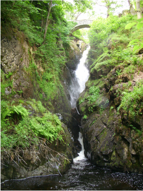
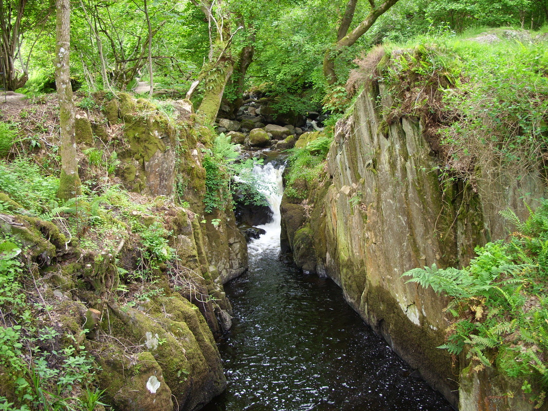
Image of Aria Force, Cumbria. Shows the gorge which has been cut out by the erosive forces of the water and the plunge pool its created in the foreground. Source own image (Simpson 2013)
|
Fluvial erosion create Waterfalls, Rapids, and Potholes
Waterfalls
Waterfalls form where hard rock and softer rock meet. The softer rock is eroded faster by the river than the hard rock which causes a step in the river bed.
Due to a lack of friction water flowing over the step increases in speed, this leads to greater erosive power, which in turn results in further erosion of the soft rock, and, undercutting of the hard rock.
Continued undercutting of the hard rock can lead to a collapse, particles of the collapsed rock are swirled around by the turbulent water and a plunge pool is carved out at the foot of the waterfall by abrasion.
Continued undercutting over time, leads to further collapse, the waterfall retreats (moves back up the channel) and leaves behind a steep sided gorge.
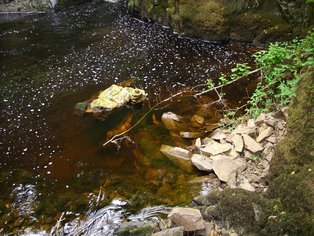
Image of collapsed rock particles at Aira Force in Cumbria. Source: own image (Simpson, 2013)
|
Steep sided channel cut through soft rock. Turbulent water can be seen in the background of the images taken at Aira Force in Cumbria. Source: own image (Simpson, 2013)
|
Potholes
Potholes are small circular holes in the river bed which are formed by abrasion. The river's bedload is swirled around by turbulence, the circular motion rubs and scrapes holes out of the river bed forming potholes.
Rapids
Rapids are sections of a river that have a relatively steep gradient. Due to the gradient of the river, turbulent water flows quickly over several sections of hard rock, creating the rapids. Rapids are, in some respects, like mini-waterfalls.
Meanders
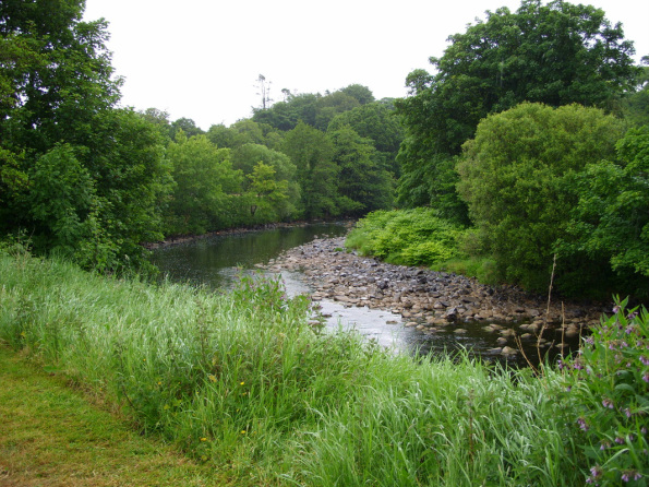
Image shows eroded material deposited on the inside of a bend on the River Roe at Roe Valley Country Park, Limavady, Northern Ireland Source own image (Simpson, 2008)
Large sweeping curves in the middle and lower stages of a river are called meanders. Meanders are formed by a combination of erosion and deposition.
Where alternating areas of deep water (pools), and, areas of shallow water (riffles) form, equally spaced, along a stretch of river bed, meanders will develop. The distance between the pools is between five and six times the width of the river. The river channel is deeper in the pools which means it is more efficient, has more energy, and erosive power. In contrast, due to friction the river loses energy as it flows over the riffles. The spacing of the riffles and pools, and, the distance between them leads to the flow of the river becoming uneven and maximum flow then becomes concentrated on one side of the river. As the water speeds up, turbulence increases within and around the pools. The water then starts to twist and coil, helicoidal flow (cork-screw like currents) develops, these currents move along the river between the pools, spiralling between the banks. The helicoidal flow increases erosion, deepens the pools further, and results in eroded material being deposited on the inside of the next bend (see image of the River Roe above), where the river loses some of it's energy. The continued processes of erosion and deposition result in the creation of the meanders' distinctive asymmetrical shape. |
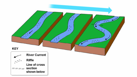
Image showing how meanders form. Source BBC Bitesize riverfeatures
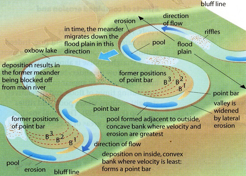
Image showing the formation of an oxbow lake. Source: Geography is easy AS formation, meanders and oxbow lakes
Oxbow lakes form from meanders that have been breached during events such as floods. The neck of the loop of the meander is broken through by the flood water, eroded material is then deposited where the neck has been broken through. The meander is then cut off from the rest of the river, leaving an oxbow lake behind.
Link to bbc learning zone clip on how an oxbow lake forms http://www.bbc.co.uk/learningzone/clips/rivers-oxbow-lakes/405.html |
Fluvial deposition causes Braiding, Flood Plains, Levees and Deltas
Braiding - a braided river is a river that has divided into many small, winding channels that eventually re-join to form a single channel again.
Braiding occurs when a river is carrying a huge amount of eroded sediment, and it's velocity either drops, or, the rivers load is so great that sediment is deposited in the channel. This results in the river dividing into multiple channels which eventually re-join and form a single channel further up stream.
Flood Plains - the areas of flat land either side of a river.
When a river overflows it's banks onto the flood plain there is an increase in wetted perimeter and a reduction in hydraulic radius. This causes an increase in friction, and a reduction in velocity, which leads to deposition of fine silt and sand over the flood plain.
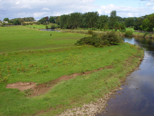
Image of a meandering river. The image shows the floodplain and levee along the banks of the River Annan, Scotland. Source: own collection, Simpson 2014
|
Levees - natural raised embankments that form as rivers overflow their banks.
During a flood eroded material is deposited across the flood plain, the heaviest material is deposited closest to the river channel and eventually builds up on the river bank and forms a natural levee.
Deltas form at the mouth of the river where it joins the ocean or a lake.
As a river reaches ocean (or other water body) its energy is absorbed by the slower moving water of the ocean. This leads to the deposition of sediment that the river is carrying. The deposited sediment (alluvium) builds up until it's level rises above sea level which partially blocks the mouth of the river. The river then has to braid into numerous distributaries forming a delta which enables the river to reach the ocean.
Rejuvenation means a river can resume vertical erosion
Rejuvenation of the river is when the base of a river is lowered, either by the crustal uplift (ground level rising) or by a drop in sea level. Rejuvenation, increases the river's potential energy and it's vertical erosion potential. The river's long profile is extended by rejuvenation and a knickpoint (sharp change in gradient e.g. waterfall) will form marking where the new and original long profiles meet.
Landforms associated with rejuvenation
River terraces - former flood plains that sit above modern day flood levels due to increased vertical erosion.
Incised meanders - deep, steep sided, winding valley, which form when vertical erosion increases and meandering rivers keep to their course. One spectacular example of an incised meander is the Grand Canyon in Arizona, USA, where you can see the Colorado River flowing deep below the original flood plain.
Sources
AQA (2012): AS & A2 Geography complete revision and practice all in one book
BBC Bitesize
BBC learning zone
coolgeography.co.uk
Geographyiseasy.wordpress.com
AQA (2012): AS & A2 Geography complete revision and practice all in one book
BBC Bitesize
BBC learning zone
coolgeography.co.uk
Geographyiseasy.wordpress.com
