River discharge
The volume of water flowing through a river per second.
Measured in cubic metres per second (m3/s), sometimes abbreviated to cumecs.
River discharge can be affected by:
Measured in cubic metres per second (m3/s), sometimes abbreviated to cumecs.
River discharge can be affected by:
- the level of precipitation - as precipitation increases, discharge levels also increase
- temperature - as temperature increases, river discharge can reduce due to increased evaporation rates
- abstraction (removal) of water from the river
Hydrographs
Hydrographs are graphs that show river discharge over time. Hydrographs show how the volume of water flowing at specific point in a river varies over time. Storm Hydrographs show river discharge around the time of a storm event. Storm Hydrographs only cover a short period of time around a particular storm event (hours and days rather than longer periods of time).
|
Peak flow (peak discharge) - the highest point on the graph when river discharge is at its highest
Basin lag time (lag time) - the delay between peak rainfall (indicated by the blue Bar Chart in the bottom left hand side of the Hydrograph) and peak flow (peak discharge) (the delay is the time it takes rainwater to flow into the river). A shorter lag time can increase peak flow (discharge), because a greater volume of water reaches the river in a shorter timeframe. Rising limb - the part of the graph up to peak flow (discharge). It shows how river discharge increases as increasing amounts of rainwater flow into the river. Recession limb (falling limb) - the part of the graph after peak flow (discharge). As less water flows into the river the rate of river discharge also falls. A shallow falling (recession) limb shows that water is entering the system from other sources after it has stopped raining. |
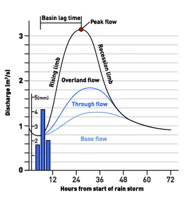
Storm Hydrograph source: http://www.bbc.co.uk/scotland/education/int/geog/rivers/hydrographs/index.shtml
|
Physical factors affecting storm hydrographs

Image demonstrating the difference between the hydrographs for elongated and circular drainage basins. Circular hydrographs are more likely to have flashy hydrographs.
D = Distance, T = Time, Rb = Bifurcation ration (the greater the bifurcation ratio the greater the risk of flooding.
Source: Geogonline
|
Drainage Basin Characteristics - the physical features of a drainage basin, can affect both lag time and peak discharge
Larger drainage basins - size affects the amount of precipitation a drainage basin can catch and hold. Large drainage basins have a higher peak discharge, and generally longer lag times than smaller drainage basins. Steep-sided drainage basins, verses, shallow-sided drainage basins - Steep-sided drainage basins have shorter lag times, because water flow faster downhill, which in turn can increase peak discharge. Circular basins - more likely to have a flashy hydrograph than long, narrow drainage basins. The reason for this is, that in a circular basin, all of the points on the watershed are approximately an equal distance from the point of discharge measurement. Which inevitably means that large amounts of water will reach the measuring point at the same time, and increase peak discharge. |
Basin that have high drainage density (lots of streams running off them) have shorter lag times because they drain quickly.
Antecedent Moisture - the amount of water already in the drainage basin - affects lag time
When the ground is waterlogged the soil cannot absorb any more moisture, this leads to a reduction in infiltration and an increase in surface runoff. Because surface runoff is faster than throughflow and baseflow, rainfall will reach rivers quicker and reduce lag time.
Rock Type - affects lag time and peak discharge
If a rock is impermeable, it will not store water and water will not flow through it. These factors reduce infiltration, increase surface runoff and reduce lag time. Peak discharge is also increased because more water will reach the river in a shorter timeframe.
Soil Type affects lag time and peak discharge
Sandy soils - have high filtration rates
Clay soils - have low infiltration rates
Low infiltration rates - increase surface runoff, reduce lag time and increase peak discharge
Vegetation - affects lag time and peak discharge
Vegetation intercepts precipitation, slowing down its movement, increasing the time it takes to reach the river channel, and increasing lag time. The rate of interception is highest when vegetation density is high and deciduous trees are in leaf. More vegetation equals more interception, this leads to more water being lost through evaporation and transpiration before it can reach the river channel.
Precipitation - affects peak discharge and lag time
Intense storms generate large amounts of precipitation and high peak discharge. In contrast, light rain showers produce less rain and lower peak discharge.
Lag time is affected by the type of precipitation - snow, for example, can remain frozen for several months.In the spring when the snow melts, the meltwater flows into the river resulting in a long lag time.
Temperature - affects lag time and peak discharge
Hot, dry conditions and cold, freezing conditions result in hard ground, reducing infiltration and increasing surface runoff, this leads to a reduced lag time and peak discharge.
High temperatures can also increase evapotranspiration, reducing the amount of water reaching the river channel and peak discharge.
Human activity and hydrographs
Man-made impermeable materials such as concrete cover a large proportion of the soil in urban areas. Due to this water is unable to infiltrate the soil, surface runoff is increased and water reaches the rivers faster. This leads to a shorter lag time and an increase in peak discharge.
Because water enters man-made drainage systems before it can infiltrate the soil or evaporate on its way to the river, man-made drainage systems affect hydrographs in a similar way and result in a shorter lag time and increased peak discharge.
Sources
AQA (2012): AS & A2 Geography complete revision and practice all in one book
bbc.co.uk/Scotland/education Geogonline
AQA (2012): AS & A2 Geography complete revision and practice all in one book
bbc.co.uk/Scotland/education Geogonline
